
A Word From “Those Idiots” Who (try to) Manage the Dam (and the lake level)
- Priscilla Treadwell
- Apr 28, 2024
- 5 min read


By Charles Tarbell
It used to seem so easy. You opened up the dam in the fall and let the lake level down where it remained mostly stable throughout the winter. Then in the spring, after the snowmelt surge, you closed up the dam to let the lake level rise to “spring full." Once Keoka achieved “spring full,” you set the dam at the two-inch mark and let nature take its course over the summer. With the natural summertime dearth of rain, the lake would fall gradually to the point that by August even the little beaches around the shoreline were enjoying increasing sand exposure. The lake level would be quite low by Labor Day. Then, the September rains would refill Keoka. There was very little summertime “monkeying” with the dam aperture necessary to achieve a water level that was traditionally satisfying to all.
That was then. Today, managing Keoka’s water at a safe level that is satisfying to all is nearly impossible. We still open the dam wide for the winter and let the level fall to its lowest point. This level anticipates runoff surges that occur with the spring snowmelt. Mostly, that low level is adequate for winter purposes, although occasionally we get surprised.
And yes, we continue to practice closing up the dam in the spring – setting it at two inches -- to get the water to a “spring full” level, from which it is expected to retreat over the course of the season.
But then, during the “season," something changed. It started about 2014, I think. Of course, we pay attention to the weather forecast, as all good Mainers do. Usually we are alerted to a forecasted storm and consider what action to take.
As an aside, Keoka has a very large watershed. Keoka has 3808 acres, which converge on the lake. For comparison, McWain Pond, another “headwaters lake,” has 2505 acres of watershed. That’s a lot of acres of thirsty trees that soak up the rain. It used to be the case that summertime storms would yield only a small stream-surge, because of all those thirsty trees. Sometimes that is still true. I’ve yet to figure out the exact cutoff – because it seems to vary based on how saturated the soil is – but it seems to me that any rain event over .5” threatens to overwhelm Keoka’s streams and surge the lake level.
So, back to that forecasted storm. The balancing act we play is this:
We hear of an impending storm two days out
The rainfall is forecast to be .5 inches
The ground is not saturated
Experience says that .5” of rainfall should absorb into the ground and trees. It should not surge the streams. Hence, we leave the dam at its default aperture and hope for the best.
Another aside: When it rains (this excludes raining over snowmelt) and the dam is set at summer level (two-inch aperture), Keoka seems to rise about 6” (vertical) for every .5” of rain (recall the large watershed). This is another reason that .5” of rainfall seems to be a “non-event." A 6” rise does not usually threaten the shoreline. However, this math changes when rainfall exceeds .5" and/or the ground is already saturated. One inch of rainfall can inundate the lake. Two inches of rainfall has the potential to float objects off beaches, float dock decking off the dock structures and erode fragile shorelines.
Back to the storm: The forecast .5” turns into 1.5” of actual rainfall. The tributary streams are surging. The lake rises, say 12”. After the rain falls, we race down and open up the dam. Water is pouring down City Brook and inundating Walkers Falls in South Waterford. Then we wait for the lake to drain.
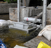
Another aside. Experience has shown that Keoka’s water level will drop .5” per day if flowing through a wide-open sluiceway. The sluiceway is the small, but deep, opening in the dam structure in which the dam gate operates. Once the water level gets up to the spillway (that’s the wide, but shallow “failsafe” in the dam structure), then much more water can leave the lake and the level declines around 1” per day. The lake must rise about 9” above the usual early summer level to get to the level of the spillway. So, if, after a heavy rainfall, 6” of water is flowing over the spillway (and it has stopped raining), then it will take 24 days (1” x 6) + (.5” x 9) to get the lake back to summer levels. That’s a long time to wait for “normal” during a short summer season.
So, that is one (small) example of the many surprises we are dealt. I can recall others in the past few years, such as:
The July 4th weekend during which we received 3” of rain. I remember my young cousins pretending to be pirates riding a washed-out footbridge down the surging stream next to my house. Needless to say, the lake level rose considerably.
The summer when it hardly rained. By mid-July, we had the dam shut tight. Still, the resulting low water level stranded some boats and made the delta at the end of Kedar Brook resemble its own continent. Note that we consider the dam “shut tight” when the aperture is at 1”. We have to allow for some flow downstream for South Waterford and Bear Pond.
The 5” of rain last December that fell onto frozen ground and quickly ran off. The streams all surged. The lake level rose over two feet vertical from its winter low. Basements in Waterford Village flooded. Docks that had been insufficiently stored floated free. The north shoreline was badly eroded by the south wind.
We keep our eyes on the forecast and try to anticipate when the dam should be opened (or closed). Sometimes we get it right. Often, we don’t. Rainfall surprise would seem to be our enemy, but it also appears that no amount of forethought and preparation can correctly accommodate rainfall of over 2," especially if the ground is already saturated, or frozen. The increasingly frequent large rainfalls, which coincide with climate change, vex our efforts to manage the lake level – not just during “the season," but year-round now.
The “Damn Team” consists of Waterford year-rounders: myself, Nick Archer, and Al Struck (recently retired). Glen Merrill, who owns the lot right next to the dam is also instrumental. He clears out debris on a daily basis. Glen also graciously allows us to access the dam across his land in the off season. We don’t like to intrude on summer activities, so we access over the (considerably longer) Western Foothills Land Trust Right of Way during the summer. We will continue to do our best to manage the dam. We welcome new members to the Dam Team who can help us keep the lake level enjoyable for all.
For more information on the Mason Dam click here.


Comments